Showing posts with label san francisco. Show all posts

Friday, June 7, 2013

Photo: Philadelphia Flyer

Yes, I forgot to post a photo again yesterday. I remembered this when I was halfway to the subway station on my way to work; that's always how it goes. Again, I apologize for the newly unreliable schedule--here I thought I could handle something every other day with no problems. NEVERTHELESS. It has been some time since I've done a transit photo here, and the recent greyness in Toronto puts me in the yen to post up something bright and green. In that idiom, while I was in San Francisco back in 2011, one of the many vehicles I captured was this shot of a restored PCC streetcar on the F Market line, wearing the 1947 colors of the Philadelphia Transportation Company--incidentally, one of the few cities represented in San Francisco's rolling streetcar museum that still runs its own.

They're not as stylish as the PCC, though. Few things can be. I mean, look at that Art Deco trim!


I, the copyright holder of this work, hereby release it under the Creative Commons Attribution-Non Commercial-Share Alike 3.0 Unported license.

This means that you are free to Share (to copy, distribute and transmit the work) and to Remix (to adapt the work) under the following conditions: Attribution (you must attribute the work in the manner specified by the author or licensor, but not in any way that suggests that they endorse you or your use of the work), Noncommercial (you may not use this work for commercial purposes), and Share Alike (if you alter, transform, or build upon this work, you may distribute the resulting work only under the same or similar license to this one).

Tuesday, June 4, 2013

Photo: A Line in the Sand

I really don't know what's up with this notice I found posted at San Francisco's Ocean Beach back in 2011. It's not as if it was a temporary thing--sure, the buses and streetcars in San Francisco are as thoroughly graffitied as this sign, but it takes time for that sort of stuff to appear. It's not as if the beach was off-limits, either; there were plenty of people there when I went, but those brutal winds coming in off the Pacific make it not so much of an actual sun destination. I suppose it's just one of those things.


I, the copyright holder of this work, hereby release it under the Creative Commons Attribution-Non Commercial-Share Alike 3.0 Unported license.

This means that you are free to Share (to copy, distribute and transmit the work) and to Remix (to adapt the work) under the following conditions: Attribution (you must attribute the work in the manner specified by the author or licensor, but not in any way that suggests that they endorse you or your use of the work), Noncommercial (you may not use this work for commercial purposes), and Share Alike (if you alter, transform, or build upon this work, you may distribute the resulting work only under the same or similar license to this one).

Wednesday, March 14, 2012

Photo: A Bridge of a Different Color

While the Golden Gate Bridge may be the iconic bridge of San Francisco for everyone who's seen it in movies or television or photographs, it's not actually the most important bridge in the Bay Area - after all, on the far side of it you'll find the rather rural Marin County. One of the linchpins of Bay Area transportation is far less well-known in the wider world - the Bay Bridge, which connects San Francisco to Oakland and which for some reason is not named after Emperor Norton even though he was calling for it to be built a hundred and forty years ago.

Here, one of the Bay Bridge's towers rises above the palm trees of the Embarcadero.


I, the copyright holder of this work, hereby release it under the Creative Commons Attribution-Non Commercial-Share Alike 3.0 Unported license.

This means that you are free to Share (to copy, distribute and transmit the work) and to Remix (to adapt the work) under the following conditions: Attribution (you must attribute the work in the manner specified by the author or licensor, but not in any way that suggests that they endorse you or your use of the work), Noncommercial (you may not use this work for commercial purposes), and Share Alike (if you alter, transform, or build upon this work, you may distribute the resulting work only under the same or similar license to this one).

Saturday, January 28, 2012

Photo: Trolley on a Mission

I never saw trolleybuses until I moved to Vancouver, and here they're all modern and top-of-the-line with digital displays and so on. San Francisco is one of the five other cities in North America that runs a trolleybus system, ant its aren't quite as new; buses such as this one on the 14 Mission route were delivered in the early 1990s and still mount the old-style signs, which I found to be a faintly strange juxtaposition in the modern day. It's just that in my experience, practically everything has gone digital by now.


I, the copyright holder of this work, hereby release it under the Creative Commons Attribution-Non Commercial-Share Alike 3.0 Unported license.

This means that you are free to Share (to copy, distribute and transmit the work) and to Remix (to adapt the work) under the following conditions: Attribution (you must attribute the work in the manner specified by the author or licensor, but not in any way that suggests that they endorse you or your use of the work), Noncommercial (you may not use this work for commercial purposes), and Share Alike (if you alter, transform, or build upon this work, you may distribute the resulting work only under the same or similar license to this one).

Thursday, December 1, 2011

Photo: By the Bay

San Francisco, on the whole, usually isn't one of those cities that you envision with a forest of skyscrapers; people who aren't from there probably think of the Golden Gate Bridge and the cable cars and that row of houses from the intro to Full House and leave the skyscrapers to New York and Chicago and so on. But they're there, and while the 260-meter Transamerica Pyramid is still the tallest in the city, it's got rivals - rivals like One Rincon Hill's South Tower, something of a misnomer as there is not and may never be a North Tower, one hundred and ninety-five meters and fifty-four stories tall. Not the tallest in the city, but brother, where it is it towers - it's not marking the gradual expansion of the skyscraper frontier, it's in a whole new area.

It's evident in this shot I took of the San Francisco skyline from Dolores Park - that's One Rincon Hill in the middle, next to the towers of the Bay Bridge. Given the way it dwarfs everything around it, I can understand why its construction was controversial.

I, the copyright holder of this work, hereby release it under the Creative Commons Attribution-Non Commercial-Share Alike 3.0 Unported license.

This means that you are free to Share (to copy, distribute and transmit the work) and to Remix (to adapt the work) under the following conditions: Attribution (you must attribute the work in the manner specified by the author or licensor, but not in any way that suggests that they endorse you or your use of the work), Noncommercial (you may not use this work for commercial purposes), and Share Alike (if you alter, transform, or build upon this work, you may distribute the resulting work only under the same or similar license to this one).

Monday, October 17, 2011

Photo: Presidio Crow

This is no Vancouver crow. I found this one in the grounds of the Presidio in San Francisco, hopping around in the grass. Look at its eyes - looks like it's not that happy about its cover being blown.


I, the copyright holder of this work, hereby release it under the Creative Commons Attribution-Non Commercial-Share Alike 3.0 Unported license.


This means that you are free to Share (to copy, distribute and transmit the work) and to Remix (to adapt the work) under the following conditions: Attribution (you must attribute the work in the manner specified by the author or licensor, but not in any way that suggests that they endorse you or your use of the work), Noncommercial (you may not use this work for commercial purposes), and Share Alike (if you alter, transform, or build upon this work, you may distribute the resulting work only under the same or similar license to this one).

Saturday, October 1, 2011

Photo: The Beer at the End of the World

The first time I went to Ocean Beach in San Francisco, I found that someone had half-buried a can of Budweiser in the sand. Why, I don't know; people have their reasons for burying things, I suppose, and a used beer can is as good as antyhing else. But it put me in an after-the-end mood, in that it's the sort of thing I could easily imagine some post-apocalyptic wanderer of the wastes stumbling upon, an ordinary aluminum can in the end was more durable than the civilization that made it.

So I took a picture.

I, the copyright holder of this work, hereby release it under the Creative Commons Attribution-Non Commercial-Share Alike 3.0 Unported license.

This means that you are free to Share (to copy, distribute and transmit the work) and to Remix (to adapt the work) under the following conditions: Attribution (you must attribute the work in the manner specified by the author or licensor, but not in any way that suggests that they endorse you or your use of the work), Noncommercial (you may not use this work for commercial purposes), and Share Alike (if you alter, transform, or build upon this work, you may distribute the resulting work only under the same or similar license to this one).

Tuesday, September 13, 2011

Photo: Finding Lost Lands in Donut World

They're always in the place you'd least expect. Scientists say that visions of Atlantis as a continent in the Atlantic aren't supported by what's known about plate tectonics and the geography of the ocean floor, but frak that noise - the sign for Donut World, somewhere in San Francisco along the N Judah line, tells me otherwise. Look closely at that map up there. Not only does it depict Atlantis, rising up along the Mid-Atlantic Ridge, there's what look to be shavings of Lemuria or Mu joining Japan and Indonesia, and the Bering land bridge appears to exist as well. Perhaps the eponymous Donut World is a parallel Earth where plate tectonics ran just slightly differently, making possible the production of donuts far beyond anything we know on our simple, seven-continented world.

I, the copyright holder of this work, hereby release it under the Creative Commons Attribution-Non Commercial-Share Alike 3.0 Unported license.

This means that you are free to Share (to copy, distribute and transmit the work) and to Remix (to adapt the work) under the following conditions: Attribution (you must attribute the work in the manner specified by the author or licensor, but not in any way that suggests that they endorse you or your use of the work), Noncommercial (you may not use this work for commercial purposes), and Share Alike (if you alter, transform, or build upon this work, you may distribute the resulting work only under the same or similar license to this one).

Friday, September 9, 2011

Photo: Buzzing the Tower

One strange thing I noticed during my time in San Francisco was how many helicopters seemed to be in the sky at any given time. While I went through the Presidio there was one Sheriff's department chopper that I could've sworn was following me at first - presumably because I lack the implants common in Americans that are used to determine how many licks it takes to get to the center of a Tootsie Roll - but it turned out to just be doing really wide circles over the area. There was also what I believe to be a UH-60 Black Hawk doing a few passes over the Golden Gate - whether it was a training flight, a patrol, or something else entirely, I have no idea.


I, the copyright holder of this work, hereby release it under the Creative Commons Attribution-Non Commercial-Share Alike 3.0 Unported license.


This means that you are free to Share (to copy, distribute and transmit the work) and to Remix (to adapt the work) under the following conditions: Attribution (you must attribute the work in the manner specified by the author or licensor, but not in any way that suggests that they endorse you or your use of the work), Noncommercial (you may not use this work for commercial purposes), and Share Alike (if you alter, transform, or build upon this work, you may distribute the resulting work only under the same or similar license to this one).

Friday, September 2, 2011

Tunnel Visions: Bay Area Rapid Transit

Every once in a while, Acts of Minor Treason hops out of New Westminster, lands in some other city with some other light- or heavy-rail transit system, and looks at different ways of getting around on two rails, whether it's on the ground, under it, or above it all.


Generally speaking, public transit systems operate in the background of life. Aside from a few freaks and weirdos like me, people tend not to take much note of them beyond knowing how to use them to get from point to point. In much the same way as the electrical infrastructure or the water supply system, they tend to be an invisible but necessary component of the modern city, remarked upon at length only when there's a perceived problem. It can be argued that a well-run transit system is one that stays out of the headlines.

There's that, and then there's BART (pronounced "bart"). That's Bay Area Rapid Transit, the regional rapid transit system serving the San Francisco Bay Area. Unlike other transit systems, which make big news when trains get derailed or budgets get cut, in the recent past BART has had the dubious privilege of wide-ranging media coverage as a result of shootings by its police force and attacks against its website and the shutdown of cell phone coverage to frustrate protests. It stands apart from the crowd.

My experience with the system wasn't enough for me to really understand how well the system's run, since it's not nearly as friendly to hop-on, hop-off travel as most city transit systems - I had to plan out my BART journeys to a degree that I've never experienced before while riding rapid transit. Still, it was enough to demonstrate the degree to which BART stands apart from the other systems you'll find across North America. Created to replace the privately-run Key System, an interurban streetcar system that served the cities of the East Bay into the 1940s and rattled across the Bay Bridge into the 1950s, today's BART almost seems like a product of a 1970s view of the future.

System

A ten-car train departs Rockridge Station, running in the center median of California State Route 24.

While BART calls itself a rapid transit network, it's really a combination of urban rapid transit and suburban commuter rail. This sort of setup is fairly common in central Europe, known in German as an S-Bahn but relatively rare outside that area. It can be argued to not even be anchored on San Francisco itself; its headquarters are in Oakland, and one of its lines serves the East Bay exclusively. It also provides the only rapid transit access to and from San Francisco International Airport, through a station connected directly to the International Terminal.

Five lines presently make up the BART system. Rather than named after a specific color or route, they're identified by their respective termini in a manner slightly reminiscent of GO Transit's convention. The Pittsburg/Bay Point-SFO/Millbrae line, for example, runs between Pittsburg/Bay Point in the north west and San Francisco International Airport and Millbrae in the south, and while it's colored yellow on maps you won't hear an official source refer to it as the "Yellow Line." With the notable exception of Marin County, on the north side of the Golden Gate Bridge - which was included in initial network plans, only to arouse popular opposition and fear that service would spur sprawl development - BART service extends across most of the Bay Area, and plans are in place for the lines that currently terminate at Fremont to be extended south to San Jose and Silicon Valley... but this isn't planned to happen until 2025, so don't hold your breath.

Most of the BART system seems to consist of at-grade trackage, either in its own right-of-way or in highway medians, though I did observe some elevated portions around Colma and in western Oakland. The main exception is in San Francisco itself, where it runs almost entirely underground; there are additional underground segment such as the Berkeley Hills Tunnel on the Pittsburg/Bay Point-SFO/Millbrae line, which I did not travel through as it is known to penetrate the Hayward Fault and I was unwilling to tempt fate, considering there's apparently slight-but-nonzero chance that a train inside the tunnel during a sufficiently powerful earthquake could be torn apart. Besides, I was busy in San Francisco anyway.

The network's key underground segment, though, isn't under that much ground at all. The Transbay Tube, which is nearly six kilometers long and takes trains four and a half minutes to travel through1, is an immersed tube on the floor of San Francisco Bay that connects downtown San Francisco to Oakland. As it carries four out of five BART lines, the Transbay Tube is the system's biggest bottleneck - my departure from San Francisco coincided with weekend track maintenance in the Tube, which shut down one set of tracks entirely and resulted in significant delays and complicated train redirections. It's sufficiently different from the remainder of BART's subway network that there's a section devoted just to it on the emergency evacuation instruction posters inside the trains.

BART is also unique in that it's almost exclusively a rail operator - the only exception is AirBART, a shuttlebus service that connects to Oakland International Airport. Aside from that, depending on where your destination is you may end up transferring from BART onto San Francico's Muni, AC Transit in the East Bay, Golden Gate Transit for journeys into Marin, and so on. Transfers to the Muni Metro are easy within downtown San Francisco, as the two agencies share the four northernmost stations of the Market Street Subway.

Two partially-used BART tickets... there's $0.70 US I'll never see again.

Where BART gets difficult, and presents ample opportunities to trip up the unwary, is in its fares. Unlike every other transit system I've ever used, there are no time-based passes available; you can't get an unlimited-use weekly, monthly, or even day pass. The closest it comes for the general public is the BART Blue High Value Ticket, which gives a 6.25% discount on the ticket price - as they're only available in $45 and $60 denominations, though, they're clearly geared toward the regular commuter riders.

BART fare media is available in two forms - the new Clipper smartcard, similar to the Los Angeles TAP card or the Presto card in the Greater Toronto Area, which is accepted by multiple Bay Area transit agencies - and physical tickets, and for visitors to the Bay Area the latter is what you're going to be dealing with. Though some stations have collectors on staff, generally you're going to be getting your ticket from a ticket vending machine. They're fairly straightforward, once you get the hang of them - you just specify the value of ticket you want, insert your payment, and it will print you a fresh ticket with a magnetic strip and the stored value printed on. As you travel through the system, you feed your ticket into the faregate readers at the departure and arrival stations and its stored value is adjusted accordingly. Once it hits zero, the faregate will open but the machine won't return your ticket, and you'll just have to get another one. The TVMs all have fare calculation tables attached so you can tell exactly how much it'll cost go anywhere from where you are. Planning out routes in advance with the fare calculator means you don't have any partially-loaded tickets left over, but it likewise restricts your freedom to tool around the system.

All BART ticket vending machines accept cash, and specialized machines take debit or credit and debit cards as well - there'll usually be at least a couple at every station, but unless a sign has been affixed (which isn't guaranteed) there's no way to tell which is which from a distance, like if you're lined up waiting to use it. What the machines don't tell you is that there are hard-coded restrictions for using credit cards. Any given credit card can only be used to purchase BART tickets twice in a twenty-four hour period; if you attempt to run it a third time, the machine will flash the message "BART Limits Exceeded," spit out a receipt for the cancelled transaction, and return to the main menu with no further explanation. This happened to me at Colma Station, which fortunately was one of the stations that had a collector on duty who was able to explain just what the hell the deal was. According to her, the restriction was put in place because BART has, in the past, experienced issues with people using stolen credit cards to buy tickets. So I can understand the policy; I just wish there had been some warning about it.2

This is another good reason to either plan out your journey ahead of time or pay cash.

Stations

The main surface structure at Downtown Berkeley Station in Berkeley, California.

BART service began in 1972, and so its station conveniently sidestepped the whole "twentieth-century prison bathroom" aesthetic you'll find so easily from Toronto to San Francisco and New York to Chicago. Architectural styles vary from the concrete brutalism of Glen Park to the windows-and-waterfalls of San Francisco International Airport to 24th St. Mission, which reminded me of Vermont/Beverly on the Red Line subway in Los Angeles. There aren't many of them, either, which is indicative of its nature as a regional rapid transit system - as of this writing there are only forty-four stations for one hundred and sixty-seven kilometers of track.

Depending on where you are, BART stations vary substantially in terms of their function. While the San Francisco stations are indistinguishable from urban subways, the suburban stations strongly cater to the commuter population - one such example is Colma Station, where the actual "station" is dwarfed by the attached parking garage. In the four shared Market Street Subway stations, the BART platforms are installed below the Muni Metro platforms, giving BART commuters temporary glimpses of the San Francisco trains rumbling in and out.

While public art isn't ubiquitous in the system, it does have a presence, such as a mural at MacArthur of what resembled a "bubbly peacock."3 Aside from the shared Market Street Subway stations, BART stations don't tend to follow the same design aside from a preference toward center platforms. They may look like they're poorly lit when you're looking out of a train's windows, but this isn't actually the case - the windows just tend to be foggy. On the whole, from the crennelated concrete walls at Balboa Park to high-ceilinged, almost hangar-like ambience at Ashby, the varying station designs lend some welcome aesthetics to the system.

They're not necessarily designed well, though. At Balboa Park, where the Muni Metro's J Church and K Ingleside lines loop for journeys back to downtown San Francisco, it seems as if BART specifically designed the station to ignore the Muni presence. Unlike in the shared Market Street Subway stations there's no signage indicating where to transfer to Muni trains, even though the loop is immediately adjacent to the station building.

As BART tends to run exceedingly long trains, with ten-car consists fairly common even in off-peak hours, the stations are accordingly large. This can become a problem for people who aren't familiar with the BART system, as while there are platform-level system maps, schedules, and information, there are only a few on any given platform; thus, you might find it only to realize the train that just left was the one you should have boarded, and it'll be fifteen minutes until the next one shows up. Plus, that assumes the map will be accurate when you find it - I found one at Embarcadero Station that, rather having been replaced with an updated version, just had stickers affixed noting that the 820 night bus line had been eliminated as of December 28, 2008.

There are also a surprising number of payphones on the platforms. I suppose they represent a vulnerable underbelly in the event that BART again suspends cell phone service within its stations.

Equipment

An aerodynamic A2 car brings up the rear of a train at Colma Station.

If I had to describe BART cars in one word? Angle-y. If they weren't so spacious, they'd put me in the mind of London Underground 1973 Stock trains. As it is, they seem like they're wider than they are high due to their angled walls - I suppose it may be to make the trains feel more open and less like a traditional subway, which would be particularly important when you've got two thousand people crammed into a crush-loaded ten-car train. There's plenty of room for standing passengers, and most of the seats are arranged in pairs of two, with armrests - no benches like on the Mark I SkyTrains, but no single seats either. The windows enhance the feeling of openness in the trains - since there's no roof-line advertising strip, the windows are able to fill all the wall space from the centerline to the roof. Advertisements in general aren't too common on BART trains, limited to the front and back ends of the individual cars - the remainder of the wall space is taken up by windows, route maps, and emergency evacuation instruction posters.

The most striking aspect of BART's rolling stock is by no means universal, but in the world of rapid transit it stands apart - some of its cars have carpeted floors. While I understand this was fairly common back in the day, most rapid transit operators have switched to using floor surfaces that are easier to clean. It's not every day you'll encounter a BART car with carpeted floors; my only encounter came at the very beginning, on the train I boarded to head into San Francisco from the airport. Still, it set a tone that was a bit "higher-class" - like this isn't just some subway.

It certainly stands apart from Muni. Graffiti is specifically prohibited on BART, and while there was some in evidence here and there was far less than on Muni, where every last LRV seemed to have its windows vandalized. The seats were comfortable as well, but whenever I sat down I couldn't help but thinking about the studies that had been conducted a couple of months previously that had discovered a vast array of antiseptic-resistant bacteria and molds clinging to the fabric. Not that it kept me from sitting down, though - subway surfing is a difficult art to master, particularly when you're unfamiliar with the idiosyncracies of a new system with unfamiliar rolling stock. Considering that BART trains aren't automated - even though they could be, apparently - rides won't necessarily always be smooth.

Ease of Access and Ease of Use

These fare gates control access to the BART platforms at Montgomery Station.

So there I was in 24th St. Mission Station, waiting for a train that would take me to Ashby Station in Berkeley so I could check out a bookstore I heard about in the area. A Dublin/Pleasanton train arrives and I let it go, because that definitely doesn't go where I need to. A Pittsburg/Bay Point train shows up and I get on because that takes me where I need to go, right? It's not until the train departs MacArthur and I'm seeing surroundings I didn't see on my original trip into Berkeley that I realize I'm on the wrong train! That's no good. For me, it underscored the importance of knowing exactly where the various lines split off from each other. Either of the lines going to Richmond would have worked for me. Considering that I was carefully planning out my route so as to not leave any money left over, though, I don't know what would have happened if a BART Police officer had inspected my fare while I was waiting for a train to get me out of Rockridge.

Even when you're aware, though, it can be difficult to make sure you're on the right train. The best way is to look at the screens on the station platforms and listen to the highly mechanical synthesized voices that announce the destination of the next incoming train. Some drivers will announce what line you're riding during station stops, but then again some won't. Rollsigns are right out; BART trains have only a single rollsign, a small digital screen on the front car, and even if the train is going slow enough to read it's hard enough to read that there's really no point at all in it being there. Why they don't have window rollsigns on each individual car, as on the Chicago 'L' or the Los Angeles Metro Rail, I have no idea.

There are no automatic station announcements on BART trains. That job is left up to the operator, who might call out the next station but then again they might not. Whether it's because the speakers in your individual car are busted or because they just don't feel like it is up for debate. Still, it feels unnecessarily unfriendly, and just because they were able to get away with it in the 1980s doesn't mean that it should continue to be that way today. That's the sort of thing I expect from penny-ante operations like Barrie Transit; BART is one of the largest rapid transit providers in the United States.

Not everything is as obvious as it could be. Take the stations outside San Francisco: at Downtown Berkeley, I came across a couple of machines that said "Take Only One When Leaving Station" but were otherwise unmarked. What it gave me was a BART to Bus transfer, a timestamped slip that can be redeemed for a round-trip single zone ride on AC Transit or Santa Clara VTA buses. It was another of the small but constant reminders that BART was tightly focused toward the use of locals, rather than people who had no experience with the system. At least that's what it seemed like to me.

As a regional transit system, and one that's substantially geared toward commuters, headways on BART are rather larger than on other systems; while this doesn't matter much in San Francisco or Oakland, it can be something to reckon with when you're going to somewhere more outlying like San Francisco International Airport - SFO/Millbrae trains arrive only once every fifteen minutes outside of the height of weekday rush hours. Though the platform information screens do give updates on how long it'll be until the next trains arrive, sometimes the information seems more like a suggestion or a guess; I can't think of any other way that the arrival times for Daly City-bound trains could be updated from 20/40 minutes to 15/19 minutes over the course of five minutes.

Conclusion

A southbound train blurs its way out of Balboa Park Station.

Despite its hybrid urban-suburban nature, or perhaps because of it, BART is one of the most well-used rapid transit systems in the United States; in the first quarter of 2011 it boasted an average weekday ridership of 357,800, behind powerhouses like the Chicago 'L' and New York Subway but well ahead of the Los Angeles network and even the Muni Metro. If considered against commuter rail networks, BART beats them all - with 354,300 weekday riders, the Long Island Rail Road comes close but not close enough. Nevertheless, it underscores the degree to which public transit is still an underdog in the States; in that same quarter the SkyTrain claimed a ridership of 349,300, with Metro Vancouver's population of 2.1 million next to the more than three million people who live in San Francisco, Alameda County, and Contra Costa County.

At its heart, I feel like BART is a system that doesn't encourage exploration. I know that the reason cities and regions build public transit networks is for people to get to point A to point B, but that shouldn't be the be-all and end-all of their existence. I would have liked to be able to hop on and off BART from one side of the Bay to the other, getting a view that wasn't confined to just San Francisco, but a fare structure geared toward long-distance commuting suburbanites made that difficult at best.

I get the impression that there are plenty of difficulties on BART. One of the first things I saw on entering San Francisco International Airport Station were information sheets in English, Chinese, and Spanish detailing "Your Rights under Title VI of the Civil Rights Act of 1964," which "requires that no person in the United States, on the grounds of race, color or national origin be excluded from, be denied the benefits of, or be subjected to discrimination under any program or activity receiving federal financial assistance." It was even more jarring than those announcements about how gambling is prohibited on the Chicago 'L' - I saw them and could only think "what the hell has gone on that they feel it necessary to have to state this front and center?"

Problems, no doubt.

1 This is an approximate figure, timed off my wristwatch, that does not include full approaches; timing began when the train descended into the tunnel surrounded by shipping containers in the Port of Oakland, and ended on the train's arrival at Embarcadero Station.

2 It is extremely possible that there were such warnings and I never noticed them, but if that's the case, I did not notice them for the entirety of my time in the Bay Area.


3 Quoting exactly from my notebook here.


Previous Tunnel Visions

Thursday, July 7, 2011

Photo: Not Your Average Canvas

For better or worse, San Francisco is easily the single most graffitied city I've ever visited. Graffiti is practically everywhere there, it seems - on the buildings, on construction equipment, on the roofs of the buses, carved into the windows of the streetcars, and on the vehicles. This particular cube van, which I found parked on Fulton out by Golden Gate Park, was just the most striking example I came across.

I've gotta admit, it certainly is one way to make your average cube van a bit more distinct.

I, the copyright holder of this work, hereby release it under the Creative Commons Attribution-Non Commercial-Share Alike 3.0 Unported license.

This means that you are free to Share (to copy, distribute and transmit the work) and to Remix (to adapt the work) under the following conditions: Attribution (you must attribute the work in the manner specified by the author or licensor, but not in any way that suggests that they endorse you or your use of the work), Noncommercial (you may not use this work for commercial purposes), and Share Alike (if you alter, transform, or build upon this work, you may distribute the resulting work only under the same or similar license to this one).

Tuesday, June 21, 2011

Photo: Streetcar in the Rain

Living in the Lower Mainland, you get used to the rain. There are plenty of places where it's far more of an occasional visitor - such as San Francisco during the summer, if my reading of the climate table is correct. Still, every once in a while the rain will come down, no matter where you are - even if you're in the Atacama Desert.

During a thankfully short San Francisco downpour, I captured this shot of Peter Witt #1815 making its way west along the Embarcadero, heedless of the storm. Though judging by the windows it looks like it may have been at least somewhat humid inside.

I, the copyright holder of this work, hereby release it under the Creative Commons Attribution-Non Commercial-Share Alike 3.0 Unported license.

This means that you are free to Share (to copy, distribute and transmit the work) and to Remix (to adapt the work) under the following conditions: Attribution (you must attribute the work in the manner specified by the author or licensor, but not in any way that suggests that they endorse you or your use of the work), Noncommercial (you may not use this work for commercial purposes), and Share Alike (if you alter, transform, or build upon this work, you may distribute the resulting work only under the same or similar license to this one).

Tuesday, June 14, 2011

Tunnel Visions: San Francisco's Muni Metro

Every once in a while, Acts of Minor Treason hops out of New Westminster, lands in some other city with some other light- or heavy-rail transit system, and looks at different ways of getting around on two rails, whether it's on the ground, under it, or above it all.


A hundred years ago, San Francisco was the first city of the West Coast. While the transformation of orange groves to sprawling suburbs in Southern California took that crown away after the Second World War, the city by the bay was nevertheless left with the sort of transit infrastructure you wouldn't otherwise expect to find west of the Mississippi. With water on three sides and the sand and scrub of the Outside Lands forcing fairly dense patterns of nineteenth-century development, San Francisco grew into the sort of city where public transit wouldn't just wither on the vine. The cable car was invented here, to overcome the city's wickedly steep hills, and today it's the only city where people still work the grip. While the San Francisco Municipal Railway's streetcar system did come under attack from politicians who believed the automobile was the wave of the future, and the scars from those years are still evident if you know where to look, it survived.

Today, transit in San Francisco is a liberal mixture of the old and the new, with a nineteenth century cable car system working hand-in-glove with twentieth century streetcars and twenty-first century light rail. Unlike other cities which tore down and built over the remnants of their original transit networks only to later rebuild them, getting around in San Francisco lets you experience history in motion. It certainly doesn't feel like any other system I've explored so far, and there may not be anything else quite like it anywhere in the world.

But at least it does go underground, so for once the title of this series is not a misnomer.

System

Outbound and inbound N Judah trains meet at the line's Ocean Beach terminus in San Francisco's Sunset District.

Transit service in the city of San Francisco is provided by the San Francisco Municipal Railway, and this has been the case for the last ninety-nine years. The system's even older than that - the modern cable car system can be traced back to 1878, and prior to 2007, the last time a new Muni Metro line was opened was 1928.1 As in Toronto, but unlike many other North American cities, San Francisco's transit infrastructure passed from private to public hands early in the twentieth century, and was thus relatively insulated from some of the problems that saw the end of streetcar service elsewhere. That's not to say that San Francisco's network lasted to the modern day intact, though - both the cable cars and the trains once served a significantly wider area. Particularly as far as the cable cars are concerned, it's due in large part to active, involved citizens that they continue to ring their bells and barrel on through at nine miles per hour.

In some respects, Muni can be understood as three systems in one. First and most important in transit infrastructure, there's the Muni Metro itself: six lines2 - J Church, K Ingleside, L Taraval, M Ocean View, N Judah, and T Third Street - that directly descend from the system of a hundred years ago, and which in many cases continue to use the same infrastructure, operating underground through downtown in the upper level of the Market Street Subway, and on the surface further out. More iconic are the cable cars, three lines which make San Francisco one of the very few cities where public transit itself acts as a tourist attraction to people other than me. Third, and perhaps least well known is the F Market & Wharves historic streetcar line, which provides regular, if tourist-crammed service between Fisherman's Wharf and the Castro with PCC and Peter Witt streetcars.3

Understandably, the system hinges on San Francisco's Financial District - they don't seem to use the term "downtown core" there - and an argument could be made that Embarcadero Station is its core. All of the Metro lines serve it, the streetcars pass above it, and the California cable car's eastern terminus is right next to it. From there, the Muni Metro unfolds in a generally southwesterly direction through neighborhoods that remind me of parts of Toronto that were previously served by streetcars, like Dupont, Harbord, or Rogers Road. The main outlier here is the T Third Street route, the newest and by far most "light rail" of Muni's lines, which is a primarily straight south route along San Francisco's eastern coast. They're powered by an overhead catenary that's usable by both the pantographs of the modern light rail vehicles and the trolley poles of the F Market & Wharves streetcars.

However, aside from Balboa Park BART Station, where the J, K, and M lines loop, there doesn't seem to be any significant connections between the lines once they exit the tunnel system and begin street running. The Muni Metro is laid out in a hub and spoke arrangement, sure, but there's no wheel to go along with it - thus, those kind of inter-line connections are dependent on the bus system.

The layout of the lines likewise hints at the infrastructure San Francisco lost in the postwar years - after all, while the Muni Metro itself may unfold to the southwest, the city has spread to fill the entire tip of the San Francisco Peninsula. In particular, you may note that the entire northwest quadrant of the city is completely unserved by rail transit, and that chunk of land between Golden Gate Park and the Presidio isn't exactly undeveloped. Back in the day, there was a streetcar through here - the B Geary, which was abandoned in December 1956. Today its replacement, the 38 Geary bus, is the most heavily-used bus route in all of San Francisco.

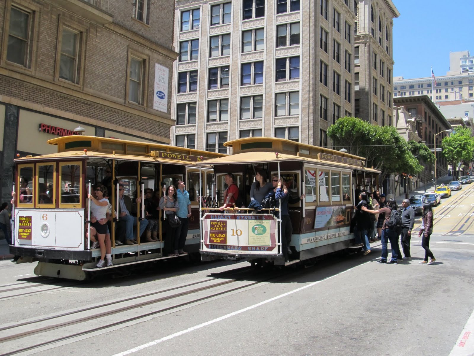
Two Powell-Hyde cable cars meet on a relatively level patch of Powell Street.

Everyone knows about the cable cars. Like the Golden Gate Bridge, they're an enduring and practically universal symbol of San Francisco. While the system was severely damaged by the 1906 earthquake and was nearly destroyed by Mayor Roger Lapham in the 1940s, today three lines remain - Powell-Hyde, Powell-Mason, and California, after the streets they primarily run along.4 The hills they climb really are that steep, as well. However, since two out of the three lines connect downtown with the tourist traps at Fisherman's Wharf, they're as much tourist attractions as they are components of the transit network - from what I've read, the California cars are the only ones regularly used by locals to a significant degree. Nevertheless, they do let you ride on the exterior running boards, an experience you can't get anywhere else without having an uncomfortable conversation with a judge at the end of it. Clinging to the bar with one hand and holding on to my camera with the other was totally one of the highlights of my time there.

Still, the cable cars do extend rail service through parts of the city that are otherwise only served by buses, and provide an alternate means to go between Market Street and the Embarcadero - definitely alternate, though, because with a top speed of fifteen kilometers per hour and tourists on every side, you're not necessarily going to get where you're going with dispatch - and besides, the Powell-Mason line's northern terminus is a couple of blocks short of the Wharf, regardless.

PCC #1077, an F Market & Wharves streetcar in the livery of the Birmingham Electric Company and bound for the Castro, waits for a traffic light to change on the Embarcadero.

If you're looking to get around on the Embarcadero, the most obvious answer is to just take the streetcar. Though the completion of the Market Street Subway in 1980 saw the Muni Metro move underground through downtown, in an unusually farsighted move the surface streetcar tracks weren't entirely ripped up. Used at first by the San Francisco Historic Trolley Festival, which ran summer service of historic streetcars from 1983 to 1987, the F Market & Wharves line began running in 1995 with a mix of restored PCC streetcars, Peter Witt cars obtained secondhand from Milan, and a handful of others from across the world. In 2000 service was extended along the Embarcadero to Fisherman's Wharf, in the space vacated by the Embarcadero Freeway - an elevated highway, similar to Toronto's Gardiner Expressway, which was demolished after sustaining serious damage in the 1989 Loma Prieta earthquake.

The streetcars are advertised as "museums in motion," and that's pretty much the case. Each of the PCCs carry the livery of a system that once ran those cars, from the Pacific Electric Railway of Los Angeles to the "Green Hornets" of Chicago and the maroon and cream of the Toronto Transit Commission - most likely the basis for the very similar historic streetcar system that Kenosha, Wisconsin opened in 2000, which I covered last year. Aside from the cards inserted in the upper windows to identify the city the individual cars hail from, there are brief descriptions of the specific system it's representing inside - that is, if you can make your way through the crush of tourists to read them. Muni presently maintains an active fleet of seventeen PCCs, but with another twenty or so stored cars in various states of restoration, it appears to have the single largest PCC fleet remaining in North America - a far cry from the late 1950s, when Toronto operated more than seven hundred of them.

Additional service on the F line is provided by a number of Peter Witt streetcars, which were one of the prominent models before the PCC came about, and which saw Canadian service in Toronto and Ottawa. There are a few other one-of-a-kind streetcars, but the only one I came across during my time in the city was one of the ones from Melbourne - and only from a distance, at that.

J Church and K Ingleside trains wait in the loop at Balboa Park, a Bay Area Rapid Transit station in southern San Francisco.

The Muni Metro has some integration with neighboring transit networks - not as far as fares go, though - making it fairly straightforward for a traveller based in San Francisco to visit sights in the East Bay or Silicon Valley. Between Embarcadero Station and Civic Center Station, the Market Street Subway is shared between the Muni Metro and BART, the San Francisco Bay Area's regional rapid transit network, with Muni above and BART below. The BART station at Balboa Park is readily accessible by J, K, and M trains, and the J train also passes within a few blocks of Glen Park BART.

Access to Caltrain, the heavy commuter rail line that links San Francisco with Silicon Valley, is by N and T trains, though weekend N trains terminate at Embarcadero. I found it a bit strange that the northern Caltrain terminus is as removed as it is from the Financial District - it's at Fourth and King, on the far side of the Bay Bridge. I've heard tales of people spending more time taking Muni the handful of stops into downtown from there than it took for Caltrain to connect their suburban stop with San Francisco. There are potential plans afoot to extend Caltrain service to the new Transbay Terminal, but even then it's not as if there'll be a Muni station right next door. I suppose I'm just spoiled from the tight integration of city public transit and commuter rail I've observed in Toronto, Montreal, Los Angeles, Vancouver...

One of the biggest issues I noticed with the Muni Metro involved its headways, the separation between trains. The most annoying part of the problem was simple - the headways are, to an average observer, completely unpredictable. Sure, if you're travelling in the Market Street Subway, it's no problem because you've got any of six lines to choose from, but that only holds true for five stations, and if things are that bad you can always go upstairs and hop on an F streetcar. Besides which, the announcements are not always accurate - if that one-car L train is three minutes away, the next announcement should not have it still three minutes away.

For outbound trains, headways might seem good at first until you pay attention to the announcements. Trains running on individual lines seem to have a standard headway of at least ten minutes, but sometimes it's far more than that. I didn't notice this myself when I was there, but the Muni Metro has very limited allowance for short-turning, even in the surface-running sections. The local tumblr A Streetcar Called Taraval went into significant detail on this recently: it's the sort of involved perspective I can't pick up over the course of a week, but which is very helpful in finding a fuller understanding of the Muni Metro system.

At least the fare is reasonable. It's $2 for a standard adult ride on the Muni system - $5 for the cable cars, though - and there are no fare zones. You'll find a much better deal in the Muni Visitor Passports, which you can buy in San Francisco International Airport just outside of the BART station and which come in one-, three-, and seven-day varieties; at the time of my visit, the seven-day pass set me back the princely sum of $26 US. They come in the form of a pocket card on which you have to scratch off the day or days it'll be active for, in essentially the same manner as a TTC Day Pass.

Muni is also working to move into the world of electronic fares; you can hardly go anywhere in the system without seeing at least an ad for its Clipper cards - they seem reminiscent of Los Angeles' TAP cards, and I would have picked one up if I'd had the option to load anything less than a monthly pass on it, but from what I've read, I can't. The constant trilling of the Clipper readers mounted near the doors of the streetcars and LRVs seems to be a ubiquitous, unavoidable part of the San Francisco transit experience.

Well, that and the graffiti. San Francisco operates what is easily the single most graffiti-heavy transit system I have ever ridden on. It's everywhere, from the back halves of articulated buses to the walls of center-platform subway stations. I'm given to understand that the windows of the new LRVs were designed to resist graffiti - and it seems to have worked, but probably not in the way they were hoping. While the sort of written graffiti that's common in the bus system isn't nearly as present on the trains, the graffiti makers adapted by the simple expedient of carving their messages. As a result, it's almost impossible to take a photograph out the window of one of the LRVs without one of those damned carvings getting in the way.

Stations

An Embarcadero-bound L Taraval train turns into West Portal Station.

There are two main kinds of stations in the Muni Metro system. The first are what the average person would think of as subway stations, which you'll find along the Market Street Subway and in the significantly older Twin Peaks Tunnel - they're underground with full platforms, fare gates, seats or benches, ticket vending machines, system maps, and so on. The second are the modern light rail stations that seem to appear exclusively along the equally modern T Third Street line, closely reminiscent of the ones you'll find along the METRO Light Rail in Phoenix... to a degree, that is.

There are nine full-on stations in the Muni Metro system: going outbound, they're Embarcadero, Montgomery, Powell, Civic Center, Van Ness, Church, Castro, Forest Hill, and West Portal, and with the exceptions of Civic Center and Forest Hill, they're named after the major street they serve.5 The Market Street Subway extends from Embarcadero to Castro, and many of the stations betray the 1970s aesthetic to which they were designed; this was particularly evident to me at Church and Castro, where earth tones and brickwork predominate. Those are also two of the stations that were strongly reminiscent of another city's network - the Montreal Metro, in this case.

The underground stations can also demonstrate the degree of San Francisco's transit history, if you look carefully. In fact, despite the small size of the underground network, it's even got an abandoned station: Eureka, just south of Castro Station, discernible where a bit of a platform opens up on the west side of the track and where the tunnel wall graffiti is particularly thick. This is also the interface between the Market Street Subway and the significantly older Twin Peaks Tunnel, itself one of the reasons why streetcar service in San Francisco wasn't entirely given over to buses. In the middle of the Twin Peaks Tunnel the trains stop at Forest Hill Station, which in terms of design stands apart from every other rapid transit station west of Chicago. I found it evocative of stations on the State Street Subway, with a healthy mix of intercity rail station: tiled walls, substantial staircases, and a truly grand and imposing surface structure that looks like it should be in the middle of downtown, with trains coming and going from every part of the country. I can't think of any other purely rapid transit stations that have this ornate of a look - it's a link back to a time where public transit occupied a much more important place in the mind of society than it does today.

Forest Hill Station is a rather imposing presence along Laguna Honda Boulevard.

West Portal, the next stop outbound, would win an award for interesting station design from me if only I gave them out. It's at West Portal that the LRVs emerge from the tunnel and commence the street-running portions of their routes, and so while the station appears ordinary enough at the north end, at the south it just ends, opening directly onto an intersection. In some respects it resembles Eglinton West Station in Toronto, but really I don't know if there's much room for comparison between West Portal and any other station.

Much like other transit systems which were active in the mid-20th century, the Muni Metro's stations are staffed by collectors who sit in the familiar fare booths and control the gates when necessary. Unlike Toronto, though, even when there's only one way through the fare gates at a station, that booth isn't necessarily going to be staffed concurrently with the station's hours - Van Ness Station, for example, was unmanned at 8 PM on a Monday. Not that that's a problem, though, considering that the Muni Metro works on the proof of payment honor system.

I don't know if Muni has an active program the same way the TTC has, but nevertheless buskers appear frequently in and immediately outside the stations, seemingly most common in the Market Street Subway stations where foot traffic is highest - the instruments tend to be varied and the effect pleasant. What wasn't as pleasant - in fact, what I'd not expected in the least - was the presence of proselytizing Scientologists, who I observed setting up a folding table stacked with copies of Dianetics and with their ubiquitous "free stress test" signs outside the fare zone of Powell Station.

An outbound N Judah train departs Brannan Station, a modern light rail stop along the eastern Embarcadero.

Beyond Embarcadero Station the rails rise to the surface again, and it's there that the Muni Metro takes on aspects of a twenty-first century transit system. Here, along the track served by N Judah and T Third Street trains, the stations reflect the modern paradigm that you can find in places like Phoenix and Los Angeles... but only to a degree. There are no fare zone markers there, no ticket machines, no platform barriers, nothing but signage and perhaps a few seats. They're absolutely the most spartan light rail platforms I've come across, and are as close to the new stops put in for the 512 St. Clair's right-of-way in Toronto as they do to the Gold Line.

Beyond that, the system's stops are traditional and reminiscent of its origins as a purely streetcar network. In some places, like Church and Duboce, you'll find low concrete islands in the middle of the street where you can wait for the next train, and in other spots you just have to keep your eyes open for the signs on the light standards. Incidentally, they can be difficult to find even if you're looking for them; I followed the J's tracks from San Jose and Milton to Church and 30th before I found a stop, but I know there were stops in between that I managed to miss. Church and 30th (or Church and 29th, perhaps - the station actually spans the distance between the two cross streets) was just the first time I noticed one that could not possibly be anything else.

Additionally, the stations themselves are wont to trip up travellers who aren't used to the nature of the trains Metro runs - specifically, the platforms are much larger than the trains. I've never heard of Muni running a train of more than two cars, but the stations look like they could accomodate six-car trains if they really needed to. This isn't just limited to the stations shared with BART, either, which does need big stations to accommodate its ten-car trains; you'll see the same in Church and Castro as well, at least. They've attempted to compensate for it by affixing "BOARDING ZONE" signage to the walls, which indicates where the train is going to stop, but if you're used to hanging out at the near end of the platform and catching the last car, you're going to have to get over your habits pretty quick.

Equipment

Peter Witt #1818, one of the two ex-Milanese cars in that city's 1930s-1970s green color scheme, rolls along Market Street.

The San Francisco Municipal Railway operates what is perhaps the single most diverse rail fleet in all of North America today, with rolling stock that spans the twentieth century and comes from all over the world. Between its cable cars, its varied collection of streetcars, and the modern LRVs that provide service along the Muni Metro lines, you can learn a great deal about the evolution of transit in San Francisco just by watching what rumbles past.

Despite their prominence in popular culture, it may come as something of a surprise that there are only forty cable cars in San Francisco - twenty-eight single-ended cars for the Powell-Mason and Powell-Hyde lines, and twelve double-ended for the California line. Many of the cars date back to the nineteenth century, though they've understandably been rebuilt multiple times since then to keep them running smoothly. You can cram sixty people into the single cars and sixty-eight into the double ones, and considering their popularity among the tourist set, it seems safe to say that they'll pretty much always be crammed like that. If you're aiming for a seat or the front end of the running boards, your best bet is to board at one of the termini so you get first pick.

Closer to the waterfront, regular service along the F Market & Wharves line is based on Muni's fleet of reconditioned President's Conference Committee and Peter Witt streetcars. They represent two distinct generations of historic streetcar service in North America - in fact, the Witts are far closer to the stereotypical old-timey trolley than anything else I've seen in revenue service. Their roots lie in the 1920s, and ninety years later they're still going strong. The PCCs are the far more recognizeable of the two, thanks to their Art Deco streamlining and their ubiquity in North America from the 1930s to the 1950s; even Vancouver ran some of them, back in the day. The PCCs themselves are unremarkable aside from their aesthetics and comfortable seats: what is interesting is that Muni also operates a few double-ended PCCs, forerunners of today's light rail vehicles in that they can be driven from both ends and require only a tail track, not a loop, at a line terminus.

Now the Witts are something else entirely. First, there's only wooden bench seating along the outer edge of the car with the center given over entirely to standing room, and if you're riding an F Market streetcar, you're going to become very well acquainted with standing room only cars very fast. Second, they're not quite as smooth as the PCCs, and they're particularly loud.6 While I could imagine PCCs returning to Toronto in numbers at some point in the future, theoretically, I can't say I could see Witts doing the same - too many Torontonians would complain. The TTC does retain one, incidentally, for occasional charters - it doesn't come out very often, though, apparently because safety regulations require that it be escorted by two CLRVs, one ahead and one behind, in case of brake failure - evidently San Francisco's Witts are made of sterner stuff.

A J Church one-car train rolls outbound through Dolores Park.

The workhorses of the system, though, are the one hundred and fifty-one Breda LRV2 and LRV3 cars - unique to San Francisco, although the Andsaldobreda P2550 currently used on the Gold and Blue Lines in Los Angeles appear to be a refinement of the San Francisco design. They're air conditioned and come with sixty seats, and on some of the rush hour runs I saw, there had to be at least that many standees crammed in as well - so the air conditioning is less a concession to San Francisco's climate, which is even more salubrious than Vancouver's, but more of a way to keep riders from drowning in their own sweat, I suppose.

The cars run in one-car and two-car configurations, but if there's any method to what seems to be madness in choosing what gets assigned where, I didn't notice it. The N Judah appears to be the only line that consistently operates two-car trains; others, like J Church and M Ocean View, seemed to run one-car trains almost exclusively, no matter the time of day. While the length of the station platforms might lead you to think that Muni could just run longer trains to deal with higher ridership, that doesn't quite work on the street; a two-car train is a hundred and fifty feet long. Double that, and I'm pretty sure there are some blocks that are shorter than the resulting train.

What I have to wonder is simple: can Muni really provide a necessary level of service with only one hundred and fifty-one cars? I mean, they're only slightly larger than the CLRVs used on the Toronto streetcar system - a system that, admittedly, has its own problems (one might say "traditions") of erratic service and customer dissatisfaction - but the TTC has a hundred and ninety-five of them in addition to the fifty-two ALRVs, which are more directly comparable to San Francisco's LRVs.

The cars are equipped with variously physical and digital rollsigns indicating their route and destination, at either end of the car and within as well. Given the conditions in the Market Street Subway, this is most welcome - if you've let the last three trains go by because they were so packed that boarding was not in the cards, you probably just want to GO, and if you've stumbled onto a J or N train as opposed to a K, L, or M, that's good information to have. It's important, incidentally, because the J and N trains leave the subway early, splitting off to the surface after departing Van Ness Station.

The LRVs also have automated announcements, but only to a point. Through the underground portion, there's a synthetic female voice that identifies the next station - though this sometimes happens only as the train is entering the station itself. Outside of the subway, though, there's nothing - no announcements save those that the operator makes, if the operator is in the mood to do so and the speakers are not so poor that you can understand what they're saying. A few times it sounded like it was one of Charlie Brown's teachers up at the controls. I don't understand why the LRVs avoid universal automated announcements. It's certainly not impossible - they manage to do it on the Toronto streetcars, and even Muni's own bus fleet has automated announcements for the next stop.

Ease of Access and Ease of Use

These fare gates control access to the Muni Metro platforms at Montgomery Station.

Like Toronto, Chicago, and Montreal, the Muni Metro's full-on stations use fare gates to control access to the fare-paid zones. The smaller ones have Clipper card readers so that you can just touch and go, but for people paying with cash or who have a Visitor's Passport to flash, you use the wider gates right next to the collector's booth. When the booth is unoccupied, those wider gates will open when you push them; I didn't try it when there was a collector around, because I didn't want to even look like I was trying to sneak in. They're physically different from the BART faregates opposite them in the shared stations, and the signage does help with that. The incompatibility of Muni and BART fare systems helps, as well.

The system seems to be more or less accessible across all of the stations - I don't recall coming across one that wasn't equipped with an elevator. Though the LRVs themselves are not low-floor, stops on the surface-running portions try to overcome this by providing ramps and platforms to allow level boarding. One other key fact about the doors is that no matter how you approach them, they won't necessarily open; sometimes you'll need to push the button.

Nevertheless, the presence of those ramps doesn't always mean there's a stop there. There's one at the Ocean Beach loop where the N Judah starts its inbound run, but that's apparently not a stop at all: so I was told by a welcomingly helpful operator, who pointed me to the actual stop a block down the street. That was just another Toronto habit coming to the fore; pretty much every loop there is also a stop in and of itself.

This crush-loaded one-car train, commonly seen even in peak travelling hours, can't do much to thin out the crowded platform at Powell Station.

I wrote earlier on the unpredictable nature of headways in the Muni Metro; it's only natural that they result in crowds that I wouldn't have been able to predict without seeing them. Seriously, at 6:15 PM on a Tuesday evening, the outbound platform at Powell Station was packed as tightly as Bloor-Yonge in the height of rush hour - and the limited size of the trains doesn't help much in relieving the pressure.

Conclusion

Next year, the San Francisco Municipal Railway will be celebrating its centennial - an appropriate time to look toward the future. Like all public transit systems it has its good parts and its bad parts, its successes and foibles. Like so many things it comes down to money - there's never enough of it, whether you're in Canada or the United States or anywhere. Sure, it has plans for expansion, but so did Toronto at this time last year. Nothing's a sure deal in the world of public transit until the rails are laid and the trains are running - and sometimes not even then.

Still, while Muni may not run the best system in the world, it's come a long way since the 1990s and the days of the claptrap Boeing streetcars. I found it simple and straightforward to get everywhere I needed to go in San Francisco by relying on its wheels. It's a bridge between the past and the future and helps bring more understanding of how things once were - and by knowing that, we're better off to confront what's heading our way next. To be honest, it makes me all the more irritated at what's been done in Toronto. The Harbourfront line started out running all PCCs at the same time as the F Market line; it could have been Toronto's answer... but no. A good number of those streetcars are in Kenosha now, being put to the use that Toronto couldn't.

Speaking of the future, I wouldn't be at all surprised to see ex-Toronto CLRVs or ALRVs cruising its rails at some point in the near-to-mid future, once the TTC's new Flexity Outlook cars finally start arriving. Decades ago, the beatniks and the rebels and the hippies went to San Francisco thanks to its tolerant, accepting nature; perhaps the same will be true for the streetcars.

In the end, though, what is the Muni Metro anyway? They list it as a light rail, but the signs in Embarcadero Station direct you down to "street cars," and the surface sections outside of the T tracks look far more like a streetcar network. Perhaps it would be more appropriate to call it a heavy streetcar system.


1 Technically there's also the S Castro Shuttle (see below), which opened in 2002, but it doesn't count.

2 Arguably seven, since there's also apparently an S Castro Shuttle run in peak hours, but I never encountered one. The F Market & Wharves streetcar, despite its identifying letter, does not count.

3 Even for me, I was only vaguely aware of it until I started actively looking; its biggest appearance in recent popular culture may have been in Monsters vs. Aliens, where Dr. Cockroach converted a Peter Witt car into an ersatz rocketplane - but how many people just assumed it was a cable car?

4 At the time of my visit, the California Street line was shut down due to infrastructure improvement.

5 If things had gone a different way, this might have only been true of Civic Center - Forest Hill Station was originally built as Laguna Honda Station. Additionally, there seems to be disagreement as to whether the word "Street" is properly included in the station names - but as the station nameplates give the street name only ("MUNI Castro" rather than "MUNI Castro Street, for example), I choose to follow that standard in this article.

6 This is apparently due to a need to rework their wheels to fit the San Francisco gauge, and not an intrinsic problem of the Peter Witt itself - but what am I saying? Streetcars are part of the WAR ON CARS! Durr...

Previous Tunnel Visions


andrew will return in tunnel visions: bay area rapid transit